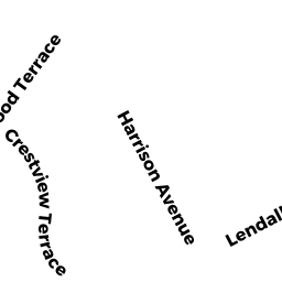
9 HARRISON TR
Owner Information
LODGE TIMOTHY A & SUZANNE E
9 HARRISON TR
GLOUCESTER, MA 01930


Property Details
9 HARRISON TR is classified as a Single Family Residential (Ranch).
The primary structure on this property was built in 1992. There are 2,208ft2 of built area within this property. There is 960ft2 of residential/living space within this property.
9 HARRISON TR is valued at $464,500. The land is valued at $192,500 and the structures are valued at $251,300. There is an additional valuation of $20,700 on this property.
This property is in Zone R-10. Confirm with local Zoning Board authorities to ensure there are no overlays or other easements on this property.
The most recent deed for 9 HARRISON TR is recorded at the local registrar in Book 20154, Page 101. 9 HARRISON TR was last sold on Tuesday, February 11, 2003 for $1.
Assessment data from fiscal year 2022.
Flood Data
According to the FEMA National Flood Hazard Layer, this property does not appear to be in a flood zone. It may also be in an area not yet reviewed. Nonetheless, confirm this information prior to taking any action.
To view the flood hazards around this property, create a FEMA "Firmette" Map of the area around 9 HARRISON TR.
Broadband Internet Providers
| Provider | Type | Bandwidth (mbps) | |
|---|---|---|---|
| Cape Ann Communications | Fixed Wireless | 20 | 20 |
| MCI | Copper Wire | 0 | 0 |
| Viasat Inc | Satellite | 100 | 3 |
| Verizon New England Inc. | DSL | 15 | 1 |
| Comcast | Cable | 1000 | 35 |
| Fusion Cloud Services, Inc. | Copper Wire | 0 | 0 |
| PAETEC Communications, Inc | DSL | 0 | 0 |
| T-Mobile | Fixed Wireless | 25 | 3 |
| GCI Communication Corp. | Satellite | 0 | 0 |
| HughesNet | Satellite | 25 | 3 |
| VSAT Systems, LLC. | Satellite | 2 | 1 |
Broadband service provider data from December 2020.
Adjacent Properties
- 8 HARRISON TR
Two-Family Residential owned by DOUCETTE THERESA I - 12 LENDALL ST
Single Family Residential owned by ROBERTS FARRELL N & ROBERTS KA - 7 HARRISON TR
Two-Family Residential owned by CRIBBS CAROLYN M & JOSEPH - 14 LENDALL ST
Single Family Residential owned by MOVALLI DAVID M & MOVALLI VIRG - 49 HARRISON AV
MUN VAC owned by GLOUCESTER CITY OF - 10 LENDALL ST
Single Family Residential owned by ASARO JOSEPH M & ASARO CRISSAN